


Stories you may like
Surveyor
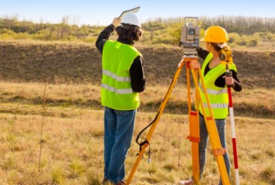
A surveyor measures and maps the Earth's surface, providing essential data for various industries such as construction, real estate, and land development. Surveyors use a combination of tools, including GPS, total stations, and drones, to accurately determine distances, angles, and elevations between points on the land. Their work is vital for establishing property boundaries, creating maps, and supporting the design and construction of infrastructure like roads, buildings, and bridges.
Surveyors often specialize in different types of surveying, such as land surveying, which focuses on determining legal property boundaries; topographic surveying, which maps the contours and features of the land; and construction surveying, which ensures that structures are built according to design specifications. Each specialization requires a keen understanding of both the technical aspects of measurement and the legal implications of land use and ownership. Surveyors frequently collaborate with engineers, architects, and urban planners, providing the foundational data needed for successful project planning and execution.
Duties and Responsibilities
The duties and responsibilities of a surveyor involve a wide range of tasks centered around measuring and mapping land, ensuring that projects are built accurately, and maintaining legal and regulatory standards. Here are some key responsibilities:
- Conducting Surveys: Surveyors perform fieldwork to measure distances, angles, and elevations using tools like GPS, total stations, and levels. They collect data on land features, property boundaries, and other physical characteristics of the terrain.
- Establishing Property Boundaries: One of the primary responsibilities of a surveyor is to determine and mark property lines, ensuring that land ownership and usage rights are clearly defined. This involves interpreting historical records, maps, and legal documents to resolve boundary disputes and establish legal property lines.
- Creating Maps and Reports: After collecting data, surveyors create detailed maps, plans, and reports that accurately represent the surveyed area. These documents are used by architects, engineers, construction teams, and government agencies for planning and decision-making.
- Ensuring Compliance with Regulations: Surveyors must ensure that their measurements and plans comply with local, state, and federal regulations, including zoning laws, land use policies, and environmental regulations. They may also provide expert testimony in legal disputes over land and property boundaries.
- Collaborating with Other Professionals: Surveyors work closely with engineers, architects, urban planners, and construction managers to provide essential data for the design and construction of infrastructure projects. Their input is crucial for ensuring that projects are built according to specifications and that land is used efficiently.
- Maintaining Survey Equipment: Surveyors are responsible for maintaining and calibrating their tools and equipment to ensure accuracy in their measurements. This includes keeping up with technological advancements and incorporating new tools, such as drones and advanced GIS software, into their work.
- Fieldwork and Data Analysis: Surveyors spend a significant amount of time in the field, collecting data in various environments and conditions. They must then analyze this data, often using specialized software, to produce accurate and useful results that inform the development of maps, plans, and legal documents.
Workplace of a Surveyor
The workplace of a surveyor is highly varied, involving a mix of outdoor fieldwork and indoor office tasks. In the field, surveyors spend much of their time outdoors, working in different environments such as urban areas, rural landscapes, forests, mountains, and construction sites. They may work in all kinds of weather conditions, navigating challenging terrain to collect precise measurements of land, boundaries, and physical features. Fieldwork often requires surveyors to travel to different locations, sometimes for extended periods, depending on the project's scope.
When not in the field, surveyors work in an office setting where they analyze the data they’ve collected. This part of the job involves using specialized software to process measurements, create detailed maps, and generate reports. The office environment is typically focused on tasks like data analysis, drafting plans, and collaborating with engineers, architects, and other professionals. Surveyors also spend time researching historical records, maps, and legal documents to ensure that their work is accurate and compliant with legal standards.
Surveyors must also maintain and calibrate their equipment, whether in the office or on-site. This aspect of their work requires attention to detail and technical know-how to ensure that all instruments are functioning correctly. Overall, a surveyor’s workplace is dynamic, balancing time between the hands-on aspects of fieldwork and the analytical, planning-focused tasks in the office. This variety makes the job both challenging and rewarding, offering opportunities to work in diverse environments and contribute to a wide range of projects.
How to become a Surveyor
High School
If you're interested in becoming a surveyor, there are a few subjects that you can focus on in high school to prepare yourself for this career path. Some of these subjects include:
- Mathematics: Surveyors use math extensively in their work, so taking courses in algebra, geometry, trigonometry, and calculus can be helpful.
- Science: Surveying often involves knowledge of science, including physics and earth science. Courses in these areas can provide a strong foundation for a surveying career.
- Computer Science: Surveyors frequently use computer software to help with data analysis and visualization, so taking courses in computer science can be beneficial.
- Technical Drawing: Surveyors also need to be skilled in technical drawing and have a good understanding of basic drafting principles.
- Geography: Surveying involves a lot of work with maps and understanding the physical layout of land, so taking courses in geography can be useful.
Formal Education
The formal education needed to become a surveyor varies depending on the state where you plan to practice. In general, surveyors typically need to have a degree in surveying or a related field and gain field experience before obtaining a license or certification from a professional organization.
Here is an overview of the typical formal education requirements to become a surveyor in the United States:
- High School Diploma or Equivalent: A high school diploma or equivalent is typically required to begin pursuing a degree in surveying.
- Bachelor's Degree: A Bachelor's Degree in Surveying Engineering or a related field, such as civil engineering or geography, is typically required to become a licensed surveyor.
- Field Experience: Many states require surveyors to gain a certain amount of field experience before becoming licensed. This can typically be gained through internships or entry-level jobs.
- Licensure/Certification: After completing a degree and gaining field experience, surveyors must typically pass the Fundamentals of Surveying (FS) exam and the Principles and Practice of Surveying (PS) exam before obtaining licensure or certification from a professional organization.
Internships
Internships can be an excellent way for students studying surveying or related fields to gain practical experience in the industry and build their skills and knowledge. To find internship opportunities in surveying, students can search online job boards, network with professionals in the industry, and check with their school's career center or academic department.
Here are some potential internship opportunities for aspiring surveyors:
- Surveying Firms: Many surveying firms offer internships for students. These internships can provide hands-on experience with surveying equipment, data analysis, and other tasks commonly performed by surveyors.
- Government Agencies: Government agencies such as the U.S. Geological Survey and state departments of transportation often offer surveying internships. These internships can provide experience with large-scale surveying projects and working with government regulations.
- Construction Companies: Construction companies often work with surveyors on projects such as site surveys and construction layout. Interning with a construction company can provide experience with surveying in the context of construction projects.
- Engineering Firms: Engineering firms often work with surveyors on projects such as transportation infrastructure and land development. Interning with an engineering firm can provide experience with surveying as part of a larger project team.
- Land Surveying Apprenticeships: Some states offer apprenticeships for aspiring surveyors. These apprenticeships typically involve a combination of classroom instruction and on-the-job training.
Licensure
Licensure is required for surveyors in order to practice as a professional surveyor in most states in the United States. The specific licensure requirements can vary by state, but typically include the following:
- Education: Surveyors must have a Bachelor's Degree in Surveying Engineering or a related field, such as civil engineering or geography.
- Experience: Most states require surveyors to have a certain amount of experience, typically two to four years, working under the supervision of a licensed professional surveyor.
- Examination: Surveyors must pass the Fundamentals of Surveying (FS) exam and the Principles and Practice of Surveying (PS) exam, which are administered by the National Council of Examiners for Engineering and Surveying (NCEES).
- Application: After completing the education, experience, and examination requirements, surveyors must apply for licensure with the state board of licensure.
- Continuing Education: Surveyors must complete a certain number of continuing education credits every year to maintain their licensure.
In addition to licensure requirements, surveyors are also often required to adhere to professional and ethical standards set forth by professional organizations such as the National Society of Professional Surveyors (NSPS). These standards can include guidelines on surveying practices, client confidentiality, and professional conduct.
Certifications
In addition to licensure, surveyors may also choose to pursue certifications from professional organizations in order to demonstrate their expertise in a particular area of surveying. Some common certifications for surveyors include:
- Certified Survey Technician (CST): The National Society of Professional Surveyors (NSPS) offers a series of four levels of CST certification, which recognize surveying technicians who have demonstrated knowledge and skill in the field.
- Certified Hydrographer (CH): The Hydrographic Society of America offers the CH certification for surveyors who specialize in hydrographic surveying, which is the mapping of underwater features and navigation hazards.
- Certified Federal Surveyor (CFedS): The Bureau of Land Management offers the CFedS certification for surveyors who work on federal lands and projects. This certification requires completion of a specialized training program.
- Geographic Information Systems (GIS) Certification: The GIS Certification Institute offers several levels of certification for professionals who use GIS software to analyze and manage geographic data. While not specific to surveying, GIS certification can be beneficial for surveyors who work with geospatial data.
Specializations
There are several specializations within the field of surveying that professionals can choose to specialize in, including:
- Geodetic Surveying: This specialization involves the measurement and mapping of large areas of land, including the earth's surface, using advanced equipment and techniques.
- Construction Surveying: This specialization involves providing precise measurements and layout services for construction projects, including roads, bridges, and buildings.
- Land Surveying: This specialization involves surveying and mapping land parcels for the purposes of boundary establishment, property division, and land use planning.
- Hydrographic Surveying: This specialization involves measuring and mapping the physical features of bodies of water, including their depths, currents, and shorelines.
- Mining Surveying: This specialization involves measuring and mapping mining sites, including underground mines, to determine the location and quantity of mineral deposits.
- Photogrammetry: This specialization involves using aerial photography and remote sensing techniques to create maps and 3D models of land and properties.
- Forensic Surveying: This specialization involves using surveying techniques to gather evidence for legal cases, including boundary disputes and accident investigations.
- Environmental Surveying: This specialization involves measuring and mapping environmental features, such as soil and water quality, for the purposes of environmental planning and resource management.
Professional Societies and Associations
There are several professional societies and associations for surveyors that offer networking opportunities, training and education, and resources for career development. Here are a few examples:
- National Society of Professional Surveyors (NSPS): This is the largest professional organization for surveyors in the United States. It offers educational opportunities, advocacy on behalf of the surveying profession, and access to resources and networking opportunities.
- American Congress on Surveying and Mapping (ACSM): This organization focuses on advancing the surveying and mapping professions through education, research, and advocacy. It offers training programs, conferences, and other resources for members.
- International Federation of Surveyors (FIG): This is a global organization that represents the surveying profession worldwide. It offers networking opportunities, training and education programs, and advocacy for the profession.
- Professional Surveyors Canada (PSC): This is the national organization for surveyors in Canada. It offers education and training programs, advocacy on behalf of the profession, and networking opportunities for members.
- Royal Institution of Chartered Surveyors (RICS): This is a professional organization for surveyors in the United Kingdom and around the world. It offers training and education programs, professional accreditation, and networking opportunities for members.
salary
The salary for surveyors can vary depending on factors like location, industry, experience, and specific job role. Here's a general overview of salary ranges for surveyors:
India:
1. Entry-level surveyor: ₹2.5 lakhs - ₹5 lakhs per year
2. Junior surveyor: ₹3 lakhs - ₹7 lakhs per year
3. Surveyor: ₹5 lakhs - ₹12 lakhs per year
4. Senior surveyor: ₹10 lakhs - ₹20 lakhs per year
5. Project manager: ₹15 lakhs - ₹30 lakhs per year
United States:
1. Entry-level surveyor: $40,000 - $60,000 per year
2. Surveyor: $60,000 - $90,000 per year
3. Senior surveyor: $80,000 - $120,000 per year
4. Project manager: $100,000 - $150,000 per year
United Kingdom:
1. Entry-level surveyor: £20,000 - £30,000 per year
2. Surveyor: £30,000 - £50,000 per year
3. Senior surveyor: £50,000 - £80,000 per year
4. Project manager: £70,000 - £100,000 per year
Keep in mind that these are general salary ranges and can vary depending on specific circumstances.
Surveyors require a diverse set of skills, including:
1. Technical skills: Proficiency in surveying software, GPS, and other technologies.
2. Mathematical skills: Strong understanding of mathematical concepts, such as geometry and trigonometry.
3. Spatial reasoning: Ability to visualize and interpret spatial data.
4. Attention to detail: Accuracy and attention to detail in measurements and calculations.
5. Communication skills: Effective communication with clients, colleagues, and stakeholders.
6. Problem-solving skills: Ability to troubleshoot and resolve issues in the field.
7. Physical stamina: Ability to work outdoors in various weather conditions.
8. Teamwork: Ability to work collaboratively with other surveyors, engineers, and construction professionals.
9. Analytical skills: Ability to analyze data and make informed decisions.
10. Knowledge of laws and regulations: Understanding of surveying laws, regulations, and standards.
Surveyors can specialize in various areas, such as:
- Land surveying: Determining property boundaries and layouts.
- Geodetic surveying: Measuring the size and shape of the Earth.
- Hydrographic surveying: Mapping bodies of water.
- Construction surveying: Providing surveying services for construction projects.
These skills and specializations enable surveyors to play a crucial role in various industries, including construction, real estate, and environmental planning.


User's Comments
No comments there.